Beachfront Property and the High-Water Mark
Beachfront land has always had great appeal to persons wanting to own a piece of paradise. In Barbados, beachfront development has ranged from as far north as Port St. Charles, all the way down to The Crane Private Residences in the South-East of the island.
Over the years, the prices of these properties have increased as the available supply of beachfront land and villas, declined. The coastline these properties sit on is also a key economic asset as a tourist attraction and an access point for fishing and maritime transport; these are among the many reasons it is a vital asset to protect.
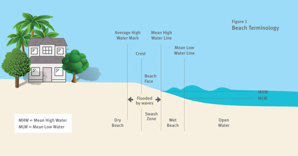
The effect of climate change has resulted in increasing instances of beach erosion and cliff instability at various locations around the island. These issues, among others, have caused the need to implement policies that ensure sustainable coastline development for the future. As there are no private beaches in Barbados, properties which front onto a beach only own the land up to the high-water mark. This is the line of the highest run up of waves at the mean tide between spring1 and neap2 tides – a concept illustrated in Figure 1 above:
Measurements to determine the high-water mark are made at the time of any ordinary high tide occurring on the sixth, seventh or eighth days before or after the day of a full moon3. Owners of beachfront property should be aware that the high-water mark can change over time, resulting in the ownership of either more or less land where there has been either beach accretion or erosion. When it comes to coastal development, an assessment by the Coastal Zone Management Unit (CZMU) is required to confirm whether development is indeed possible. If so, buildings are generally required to be constructed with a set-back4 of 30m (100 feet) from the high-water mark on a beach, or 10m (30 feet) for cliffs, measured from the landward point of cliff under cut5 . It is possible, however, that exceptions to this rule may be approved by the Minister with responsibility for Planning6 . For example, an increase in the setback so as to preserve and conserve unique landscape features along the coastline, or decreases in setbacks in areas where there are existing buildings.
Whether you’re taking advantage of the Special Development Areas Act, or building the home of your dreams, with any beachfront property, the high-water mark is worth knowing.
1. Spring tide occurs just after a new or full moon, when there is the greatest difference between high and low water.
2. A neap tide occurs just after the first or third quarters of the moon when there is the least difference between high and low water.
3. As defined by the Coastal Zone Management Act Cap.394, Section 32.
4. The set-back is the required seaward limit of major construction for a coastal property in Barbados
5. This is the point where waves have eroded a cliff’s base forming an indentation referred to as a “wave cut notch”, causing instability in the cliff over time.
6. Stipulated in Section 18(1) of the Town Planning Act Cap.240.
Beachfront Property and the High-Water Mark